 PRICE :
Innitial --> Rp. 385.000,00
STATUS : Available
|
|
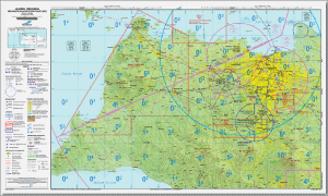
| Code |
: |
ANC |
| Name |
: |
Aeronautical Navigation Chart 1:250.000 |
| Type |
: |
CHART |
| First Published |
: |
2013 |
| Description |
: |
Like the VFR cross-sectional graph they complement, the terminal area diagram illustrates topographic features and other interesting information for visual fly pilots, including landmarks, field elevation, visual navigation routes, ground-based navigation assistance, airports, rivers, cities and airspace. . TAC is more detailed than cross-sectional graphics, and scaled at 1: 250,000 (as opposed to 1: 500,000 for cross-sectional graphics) to allow for more inclusion. TAC contains information on transitional rules, transition procedures, departures, and transitions, rules and regulations for the crowded Class B area around the main airport.
The terminal chart for Indonesia is maintained and published by Indoavis Nusantara. which is based on government data sources by AIP (Aeronautical Information Publication) and NOTAM Perm.
For the territory of Indonesia and the surrounding countries, Indoavis is divided into 148 pieces of paper, covering 4 (four) neighboring countries and as many as 220 sheets of digital format (Geotiff).
ANC paper format is updated at six-month intervals. |
|