 |
 |
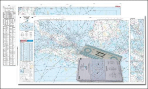
Coverage :
Indoavis En-Route chart is intended for flight operations in Indonesia with scope covers the territory of Indonesia |
|
Information :
Indoavis IFR HIGH/LOW ALTITUDE ENROUTE CHART are compiled and constructed using the best available aeronautical reference charts. Most Indoavis Enroute Charts use the Mercator projection. The design is intended primarily for airway instrument navigation to be referenced to cockpit instruments. Charts are identified by code letters for Indonesia only areas covered by a series, by parenthetical letters for the altitude coverage, and by numbers for the individual chart. |
|
Aeronautical :
1. Limit and Clarification of Designated Upper Airspace.
2. Airspace structure and Airspace Restricted Areas
3. Aerodrome point
4. Cruising Levels, Navigation Aids
6. Radio Communication Frequencies within indonesia
7. International and Domestic Route.
8. Bearing and Distance to point
9. FIS frequencies |
Topograpichal :
Basic sea line is from digital chart of the world (DCW) |
Doc. Reference :
Annex-4 (Aeronautical Chart)
Doc-8697 (Aeronautical Chart Manual) |
Remarks :
|
|